Shortgrass Bird
Conservation Region
Introduction
At the western edge of the North American grasslands, where the Great Plains
meet the Rocky Mountains, the shortgrass prairie stretches along a broad,
north-south band. Early explorers referred to the area as desert, an
understandable assessment given that the low-growing plant life is brown for
much of the year, save a spring flush of wildflower color. The brown color and
low vegetation result from a semi-arid climate, drier than the mixed-grass and
tallgrass prairies farther east. Birds adapted to this habitat include raptors
that build nests with bison and cattle bones, because so few sticks are
available on the plains, owls that live underground, and skylarking sparrows
that ignore the meager low perches to sing in flight instead.
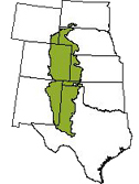 Overlaid on this landscape is the Shortgrass Prairie Bird Conservation Region
(BCR), which covers more than 148,000 square miles of South Dakota, Nebraska,
Wyoming, Kansas, Colorado, Oklahoma, New Mexico, and Texas. Most of the land is
privately owned, with some tribal, state, and federal lands. State lands
include parks, wildlife areas (managed primarily for hunting and fishing), and
lands leased to the private sector for agriculture. The principal federal
holdings in the region are U.S. Forest Service National Grasslands: Pawnee and
Comanche in Colorado, Kiowa in New Mexico, Rita Blanca in Texas and Oklahoma,
Oglala in Nebraska, and Cimarron in Kansas.
Overlaid on this landscape is the Shortgrass Prairie Bird Conservation Region
(BCR), which covers more than 148,000 square miles of South Dakota, Nebraska,
Wyoming, Kansas, Colorado, Oklahoma, New Mexico, and Texas. Most of the land is
privately owned, with some tribal, state, and federal lands. State lands
include parks, wildlife areas (managed primarily for hunting and fishing), and
lands leased to the private sector for agriculture. The principal federal
holdings in the region are U.S. Forest Service National Grasslands: Pawnee and
Comanche in Colorado, Kiowa in New Mexico, Rita Blanca in Texas and Oklahoma,
Oglala in Nebraska, and Cimarron in Kansas.
Read More